The Pyg Track Snowdon stands as one of the most popular and scenic routes to the summit of Mount Snowdon (Yr Wyddfa), the highest peak in Wales at 1,085 meters. This historic path offers breathtaking panoramic views of the surrounding Snowdonia National Park and provides hikers with a challenging yet accessible ascent through diverse terrain. The Snowdon Pyg Track begins at Pen y Pass car park and stretches approximately 5.5 kilometers to the summit, attracting thousands of adventurers annually who seek to conquer Wales’ most iconic mountain. Whether you’re an experienced hiker or a determined novice, this guide provides essential information to help you prepare for and enjoy your journey along this magnificent mountain route.
Quick Facts About the Pyg Track
The Pyg Track Snowdon difficulty is classified as moderate to challenging, making it suitable for reasonably fit hikers with some mountain experience. This route offers the most direct path to Snowdon’s summit from Pen y Pass:
- Distance: The Snowdon Pyg Track distance is approximately 5.5 kilometers (3.4 miles) one way
- Elevation Gain: Around 800 meters (2,625 feet)
- Average Time: 3-4 hours ascent, 2-3 hours descent
- Starting Point: Pen y Pass car park (altitude: 359 meters)
- Difficulty: Moderate to challenging
- Terrain: Rocky paths, some scrambling required in sections
- Best Time to Visit: May to October (weather dependent)
While not the most technically difficult path up Snowdon, the Pyg Track requires a reasonable level of fitness and appropriate footwear. The route features some steep and rocky sections but rewards hikers with spectacular views of Snowdonia’s mountains and lakes. As you continue reading, you’ll discover everything you need to know about planning your Pyg Track adventure.
Getting There
Reaching the starting point of the Pyg Track Snowdon is relatively straightforward, though planning your journey in advance is essential, especially during peak season when transportation options can be limited.
By Car
The Pyg Track begins at Pen y Pass, located on the A4086 between Llanberis and Capel Curig. From the A55 North Wales Expressway:
- Take the A470 south toward Betws-y-Coed
- Continue to Capel Curig and follow the A4086 west toward Llanberis
- Pen y Pass car park will be on your right after approximately 5 miles
By Public Transport
- Sherpa Bus Service: The Snowdon Sherpa bus network connects surrounding villages to the mountain paths, including the Mount Snowdon Pyg Track. Routes S1, S2, S3, and S4 all provide access to Pen y Pass.
- Train: The nearest mainline station is in Bangor, from where you can take a bus to Llanberis and then connect to the Sherpa service.
Organized Tours
Several local operators offer guided hikes and transportation packages to Snowdon, which can be convenient for visitors without personal transportation.
Be aware that reaching Pen y Pass during summer weekends and holidays can be challenging due to traffic and limited parking. Planning to arrive early or using the park-and-ride services will help ensure a smooth start to your hike. Next, we’ll cover the crucial parking information you’ll need to know.
Parking for the Pyg Track
Finding parking for the Pyg Track Snowdon car park can be one of the most challenging aspects of your trip, especially during peak hiking season (April-October). Advance planning is essential to avoid disappointment.
Pen y Pass Car Park
- Capacity: Approximately 65 spaces
- Cost: £18 for 8 hours (as of 2024)
- Booking: Pre-booking is mandatory through the Snowdonia National Park website
- Hours: The car park fills extremely quickly, often by 6:30 am on weekends
Alternative Parking Options
When the Pen y Pass car park is full (which happens frequently), consider these alternatives:
- Nant Peris Park & Ride:
- Located approximately 5 miles from Pen y Pass
- £5 all-day parking
- Regular Sherpa buses to Pen y Pass (additional fare applies)
- Llanberis Car Parks:
- Multiple locations with varying rates
- Connect to Pen y Pass via Sherpa buses
- Option to take the Llanberis Path instead or combine routes
- Pen y Gwryd Hotel:
- Limited spaces available about 1 mile from Pen y Pass
- Requires a short walk to reach the trailhead
During summer weekends and bank holidays, arriving by 6:00 am is recommended if you’re determined to park at Pen y Pass. Alternatively, using the park and ride services eliminates parking stress and contributes to reducing congestion in the national park. With parking sorted, let’s examine the facilities available at Pen y Pass before you begin your ascent.
Facilities at Pen y Pass
Before embarking on your Pyg Track Snowdon adventure, it’s worth knowing what amenities are available at Pen y Pass to help you prepare for your hike.
YHA Pen y Pass
The Youth Hostel Association operates a facility at Pen y Pass offering:
- Café serving hot food, snacks, and beverages (open to non-residents)
- Public toilets
- Water refill station
- Basic hiking supplies
- Information desk with maps and advice
National Park Facilities
- Outdoor information boards with route maps
- Emergency telephone
- Ranger station (staffed seasonally)
Operating Hours
The YHA café typically operates from 8:00 am to 5:00 pm, though hours may vary seasonally. During peak summer months, services may be available for longer hours, while winter sees reduced operations.
Remember that once you leave Pen y Pass, there are no facilities until you reach the summit’s Hafod Eryri visitor center (open seasonally from late spring to October). Even when open, summit facilities can be closed due to adverse weather conditions. Always carry sufficient water, food, and emergency supplies regardless of the season or facility availability. With your preparations complete at Pen y Pass, let’s explore what you’ll encounter along the trail itself.
Path Description
The Pyg Track Snowdon journey begins at the clearly marked trailhead at Pen y Pass car park. This detailed route description will guide you through each section of this historic and scenic path.
Starting Out (0-1 km)
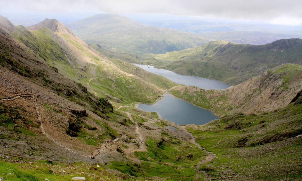
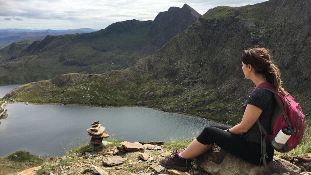
From the car park, follow the clearly marked signs for the Pyg Track Snowdon. The path initially climbs a well-maintained stone staircase before leveling out somewhat. Within the first kilometer, you’ll be rewarded with spectacular views of Llyn Llydaw below and the imposing Crib Goch ridge to your right. The path here is relatively wide and stable underfoot.
Middle Section (1-3 km)
After the initial climb, the path traverses the northern slopes of Snowdon, maintaining a relatively steady gradient:
- You’ll cross a small stone bridge over a mountain stream
- The path narrows in sections with some rocky terrain
- At approximately 2 km, you’ll reach a junction where the Miner’s Track joins from the right
- Continue straight ahead, following signs for the Pyg Track
- The path becomes increasingly rocky with occasional scrambling required
This middle section offers stunning views of Snowdon’s horseshoe and the lakes below. On clear days, you can see as far as Anglesey and the Irish Sea.
The Zigzags (3-4.5 km)
The most challenging section begins as the path steepens considerably:
- The trail zigzags up the mountainside through rocky terrain
- Some sections require using hands for stability (light scrambling)
- The exposure increases, though the path remains well-defined
- Weather conditions often deteriorate in this section, with increased wind
Final Ascent (4.5-5.5 km)
The last kilometer brings you to Bwlch y Moch (the pass of pigs), where:
- The Pyg Track joins the Miner’s Track completely
- You’ll encounter the intersection with the Llanberis Path and Snowdon Ranger Path
- The final approach follows the ridge to the summit
- The terrain is rocky and can be slippery in wet or icy conditions
At the summit, you’ll find Hafod Eryri visitor center (when open) and the famous summit marker, along with 360-degree panoramic views across Snowdonia and beyond. With the route description complete, let’s examine the key distances and timings to help you plan your hike effectively.
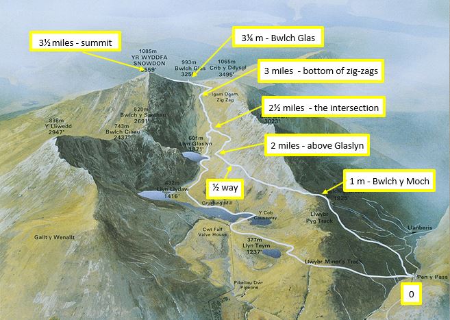
Distances up the Path
Understanding the key milestones and timing expectations for the Pyg Track Snowdon time helps hikers plan their journey effectively. While hiking speeds vary based on fitness, weather conditions, and stopping time, these estimates provide a useful framework.
Key Segments and Timings
| Segment | Distance | Elevation Gain | Average Time | Notable Features |
| Pen y Pass to Llyn Llydaw viewpoint | 1.2 km | 150 m | 30-45 mins | First major viewpoint |
| To Miners’ Track junction | 2 km | 200 m | 45-60 mins | Path intersection |
| To Zigzag section start | 3 km | 300 m | 1.5-2 hours | Increasing difficulty |
| To Bwlch y Moch | 4.5 km | 600 m | 2.5-3 hours | Trail convergence |
| To Summit | 5.5 km | 800 m | 3-4 hours | Final achievement |
The total Snowdon Pyg Track time for a round trip (up and down) typically ranges from 5-7 hours, depending on your pace and rest stops. Most hikers find the descent takes approximately 2-3 hours.
Elevation Profile
- Starting elevation at Pen y Pass: 359 meters
- Summit elevation: 1,085 meters
- Total elevation gain: approximately 800 meters
The gradient is relatively steady until the zigzag section, where it increases significantly. This final third of the hike is where most people find themselves slowing down considerably.
Many hikers find using the ‘Naismith’s Rule’ helpful for planning: allow 1 hour for every 5 km of distance, plus 1 hour for every 600 meters of ascent. With these distance and timing considerations in mind, let’s explore how you might combine the Pyg Track with other routes for a more varied Snowdon experience.
Safety Considerations
The Pyg Track Snowdon deaths that have occurred over the years serve as a sobering reminder that mountain hiking carries inherent risks, even on popular routes. While the Pyg Track is not considered technically difficult, several factors can create dangerous conditions.
Weather Dangers
- Sudden weather changes are common, with visibility dropping to near-zero within minutes
- Strong winds can make exposed sections treacherous
- Low temperatures, even in summer, can lead to hypothermia if unprepared
- Lightning strikes pose a risk during thunderstorms
Essential Safety Precautions
- Check weather forecasts specifically for Snowdon summit before departing
- Carry appropriate equipment: map, compass, first aid kit, whistle, headlamp
- Wear proper footwear and clothing, including waterproofs and warm layers
- Bring sufficient water and food, plus emergency supplies
- Tell someone your route and expected return time
- Consider downloading the OS Locate or What3Words app for emergency location sharing
When to Turn Back
- If visibility drops significantly
- In case of electrical storms
- If you become injured or excessively fatigued
- When daylight hours are limited (avoid descending in darkness)
Mountain rescue teams respond to hundreds of incidents on Snowdon annually, with most being preventable through proper preparation and decision-making. Respect the mountain environment and know your limitations. With safety in mind, let’s explore how you can combine the Pyg Track with other routes for a more varied Snowdon experience.
Combining with Other Paths
The Snowdon routes Pyg Track experience can be enhanced by combining it with other paths to create circular or varied journeys. These combinations offer different perspectives of the mountain and can help you avoid retracing your steps.
Popular Route Combinations
- Pyg Track Up, Miners’ Track Down
- The most popular combination
- Offers varied scenery with minimal additional navigation
- Allows closer views of the lakes on descent
- Total distance: approximately 11 km
- Pyg Track Up, Llanberis Path Down
- Requires transport arrangement between Pen y Pass and Llanberis
- Llanberis Path is gentler for descent
- Passes through different terrain and landscapes
- Total distance: approximately 13 km
- Crib Goch, Pyg Track Circuit
- For experienced mountaineers only
- Incorporates the challenging Crib Goch ridge
- Creates a partial horseshoe route
- Requires excellent weather conditions and scrambling experience
Navigation Considerations
When combining routes:
- Ensure you have maps covering all paths
- Study the junction points before setting out
- Be aware that some combinations require transportation arrangements
- Allow extra time for navigation at intersection points
- Consider visibility conditions for route-finding at junctions
The flexibility to combine the Pyg Track with other routes is one of the attractions of Snowdon, allowing repeat visitors to experience different aspects of the mountain. Before planning a combination route, it’s important to understand the time requirements for completing your hike.
Time Planning and Best Seasons
Understanding how long to climb Snowdon Pyg Track is crucial for safe and enjoyable hiking. While individual times vary considerably based on fitness, experience, and conditions, these guidelines will help you plan effectively.
Average Completion Times
- Fit, experienced hikers: 2.5-3 hours ascent, 2 hours descent
- Average fitness hikers: 3-4 hours ascent, 2-3 hours descent
- Beginners or families: 4-5 hours ascent, 3 hours descent
These times exclude breaks, photography stops, and summit time. Most hikers should plan for a 6-8 hour round trip in total, including rest periods.
Seasonal Considerations
The Mount Snowdon Pyg Track experience varies dramatically by season:
- Spring (April-May):
- Beautiful wildflowers and fewer crowds
- Potential for lingering snow patches
- Unpredictable weather transitions
- Summer (June-August):
- Most popular season with busiest trails
- Best chance of clear summit views
- More reliable weather (though never guaranteed)
- All facilities open
- Autumn (September-October):
- Spectacular colors on the mountainside
- Fewer crowds after school holidays
- Increasing chance of mist and rain
- Cooler temperatures requiring additional layers
- Winter (November-March):
- Requires winter mountaineering skills and equipment
- Significantly more dangerous with snow and ice
- Shorter daylight hours limiting hiking time
- Most facilities closed
For most recreational hikers, the period from late May to early October offers the best balance of accessibility and safety. With timing considerations covered, let’s look at some useful maps and resources to aid your journey.
Maps and Navigation
Having a reliable Pyg Track Snowdon map is essential for safe navigation, especially when visibility deteriorates. While the path is well-trodden and marked in good conditions, proper navigation tools remain crucial.
Recommended Maps
- Ordnance Survey Explorer OL17 (1:25,000)
- The gold standard for detailed navigation
- Shows contour lines, paths, and features clearly
- Waterproof versions available
- Harvey Mountain Map – Snowdon (1:25,000)
- Specifically designed for mountaineers
- Lightweight and waterproof
- Clear route markings
Digital Navigation Resources
The Snowdon Pyg Track map is available on several digital platforms:
- OS Maps app: Provides GPS location on digital OS maps
- ViewRanger/Komoot: Offers downloadable routes with navigation
- Snowdonia National Park official app: Includes route information
Key Navigation Points
| Location | Grid Reference | Description | Navigation Tip |
| Pen y Pass starting point | SH 647 556 | Car park and trailhead | Clear signage for Pyg Track |
| Miners’ Track junction | SH 639 551 | Path intersection | Continue straight for Pyg Track |
| Zigzag section start | SH 629 552 | Steepening terrain | Path becomes more defined |
| Bwlch y Moch | SH 615 551 | Multiple path junction | Follow signs to summit |
| Summit | SH 609 543 | Mountain peak | Distinctive marker and building |
Remember that electronic devices can fail due to battery issues, extreme cold, or water damage. Always carry a physical map and compass as backup, and know how to use them. Understanding your location on the mountain is vital for safety and for planning the remainder of your journey.
Conclusion
The Pyg Track Snowdon represents one of Britain’s most iconic mountain walks, offering a perfect balance of challenge and accessibility for hikers seeking to conquer Wales’ highest peak. Throughout this guide, we’ve covered everything from practical parking information to detailed path descriptions and safety considerations for your journey along the Snowdon Pyg Track.
Whether you’re planning your first ascent or returning to explore different route combinations, remember that mountain environments demand respect and preparation. Check weather forecasts before departing, carry appropriate equipment, and know your limitations.
For more information about exploring Snowdonia National Park, visit our homepage or browse our detailed guides to other spectacular mountain walks in Wales. If you’re interested in other approaches to Snowdon, our comprehensive guides to the Llanberis Path and Miners’ Track provide additional options for your adventure.
We’d love to hear about your experiences on the Pyg Track or answer any questions you might have. Leave a comment below or contact us directly to share your Snowdon stories.
Whatever route you choose, the magnificent views and sense of achievement await you at the summit of Yr Wyddfa. Safe travels on your mountain adventure!